Robert Cheek's Land
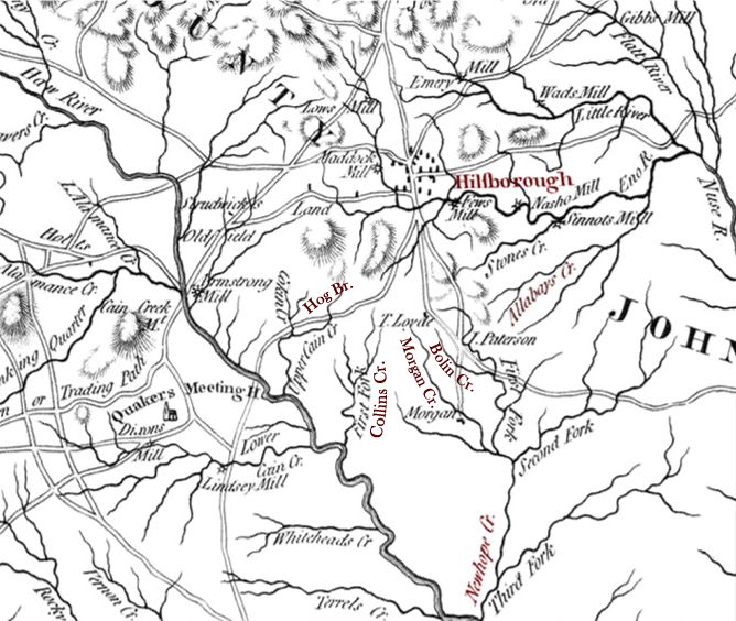
Henry Mouzon's map of North Carolina, first published in 1775, shows the location of the major creeks and
rivers surrounding Hillsborough, North Carolina. The Cheek family
lived in the upper branches of New Hope Creek![]() , which flows south
from Hillsborough to the Haw River. Notable entries on this map
include T. (Thomas) Lloyd, a prominent local resident and British
loyalist; the Cane Creek Quaker Meeting House; Lindley's
Mill on Cane Creek, site of a battle during the Revolutionary
War; and J. (James) Patterson, who owned a tavern at the crossing of the two main roads on New Hope Chapel Hill.
, which flows south
from Hillsborough to the Haw River. Notable entries on this map
include T. (Thomas) Lloyd, a prominent local resident and British
loyalist; the Cane Creek Quaker Meeting House; Lindley's
Mill on Cane Creek, site of a battle during the Revolutionary
War; and J. (James) Patterson, who owned a tavern at the crossing of the two main roads on New Hope Chapel Hill.
Other families in the area who intermarried with the Cheeks
include William Andrews,
Sr., who lived on Morgan Creek and Hog Branch, and John Edwards, Sr., who owned land on Collins Creek,
Ellerbe (Allabays) Creek, and Marks Creek (possibly an early name for Bolin Creek).
 Previous Page


